
num. 1-6 giugno 2009

back to index
 |
page 006 |
 |
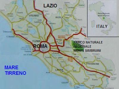
il Parco Naturale Regionale dei Monti Simbruini
|
A cavallo tra Ie Province di Roma e Frosinone, su un territorio di 29.990
ha, si estende il Parco Naturale Regionale dei Monti Simbruini, la piu
vasta area protetta del Lazio. ll territorio abbraccia sette Comuni,  situati tra 408 e 1075 m: Jenne, sede dell’Ente, Subiaco, Camerata Nuova, Cervara di Roma, Filettino, Trevi nel Lazio e Vallepietra. Il nome Simbruini deriva dal
latino sub imbribus, "sotto le piogge", e testimonia la grande importanza che
l’acqua riveste in questo scenario. situati tra 408 e 1075 m: Jenne, sede dell’Ente, Subiaco, Camerata Nuova, Cervara di Roma, Filettino, Trevi nel Lazio e Vallepietra. Il nome Simbruini deriva dal
latino sub imbribus, "sotto le piogge", e testimonia la grande importanza che
l’acqua riveste in questo scenario.Gia gli antichi romani utilizzavano intensamente la grande risorsa acqua: l'imperatore Nerone costruì una villa nei pressi di Subiaco lungo il corso del fiume Aniene, con tre laghi artificiali, ma soprattutto furono edificati imponenti acquedotti per alimentare l’Urbe (l’Anio Novus, il Marcio e il Claudio). Ancora oggi le sorgenti presenti nel territorio del Parco forniscono acqua potabile alla Capitale. ll territorio, prevalentemente montuoso, è caratterizzato dalla presenza di due corsi d'acqua: il fiume Aniene, che nasce in uno dei luoghi più suggestivi del Parco in localita Fiumata nel Comune di Filettino, e il torrente Simbrivio, che ha origine poco a monte dell’abitato di Vallepietra sotto il santuario della SS. Trinità.  Ai due fiumi fanno da contorno le montagne del sistema orografico dei Simbruini: le vette suggestive del Monte Viglio (2156 m) e
il Monte Tarino (1961 m), il Monte Autore (1855 m) da cui si gode uno spettacolo particolarmente suggestivo e il Monte Cotento (2015 m che domina l'abitato di Filettino. La catena montuosa è interrotta da vari pianori di origine carsica, aree pianeggianti circondate da pendici ammantate di faggete, dove non è raro trovare doline ed inghiottitoi che testimoniano il lavoro secolare dell'acqua sulla matrice rocciosa. La Grotta dell’Inferniglio Ai due fiumi fanno da contorno le montagne del sistema orografico dei Simbruini: le vette suggestive del Monte Viglio (2156 m) e
il Monte Tarino (1961 m), il Monte Autore (1855 m) da cui si gode uno spettacolo particolarmente suggestivo e il Monte Cotento (2015 m che domina l'abitato di Filettino. La catena montuosa è interrotta da vari pianori di origine carsica, aree pianeggianti circondate da pendici ammantate di faggete, dove non è raro trovare doline ed inghiottitoi che testimoniano il lavoro secolare dell'acqua sulla matrice rocciosa. La Grotta dell’Inferniglio 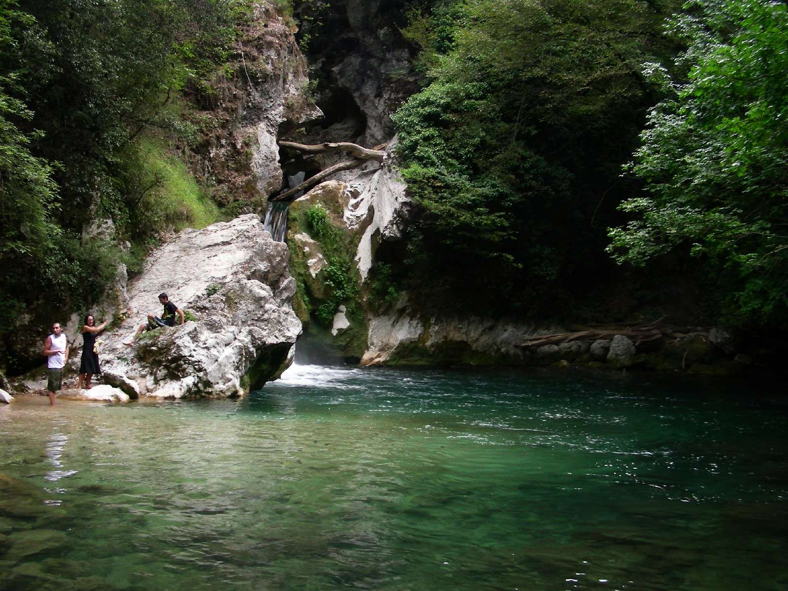 nel comune di Jenne e
il Pozzo del Gelo a Camerata Nuova ne sono un esempio. Tra gli altopiani carsici più interessanti si segnalano quelli di Camposecco, Campaegli, Campo Buffone, Fondi e Ceraso. nel comune di Jenne e
il Pozzo del Gelo a Camerata Nuova ne sono un esempio. Tra gli altopiani carsici più interessanti si segnalano quelli di Camposecco, Campaegli, Campo Buffone, Fondi e Ceraso.
|
The Regional Natural Park of the Simbruini Mountains, the most extensive
protected area of Regione Lazio, extends over a territory of 29.990 ha, between the Provinces of Rome and Frosinone. The territory embraces seven
Communes, situated among 408 and 1075 meters on the level of the sea: Jenne
(local authority center), Subiaco, Camerata Nuova, Cervara di Roma, Filettino,
Trevi nel Lazio and Vallepietra. The Simbruini derive their name from the Latin
sub imbribus, "under the rains" that it testifies the great importance that water
assumes in this scenery. Already the ancient Romans knew and they used the great resource water, the emperor Nerone built a villa (of which is possible to visit the ruins) near Subiaco along the course of the river Aniene, with three artificial lakes, but above all imposing aqueducts were built for feeding the Urbe: the "Anio Novus", the "Marcio" and the "Claudio". Even today the sources in  the territory of the Park furnish water to the Capital and the hinterland. The territory,
primarily mountainous, is characterized by the presence of two courses of water:
the river Aniene, that is born in one of the most suggestive places, "Fiumata" in
the Commune of Filettino, and the stream Simbrivio, that has his origin near
Vallepietra under the famous sanctuary of the Holy Trinity. Numerous sources
feed them during their run, gushing out unexpected from the ravines of the calcareous rocks with their ripples similar to a concert of the nature. The mountains
of the orographic system of the Simbruini serve as contour to the two rivers: the
suggestive peaks of Monte Viglio (2156 m), of Monte Tarino (1961 m), of Monte
Autore (1855 m) from which you can enjoy a suggestive view, and of Monte
Cotento (2015 m) that dominates the inhabited area of Filettino. The mountainous chain is interrupted from various highlands of karstic origin, flat lands surrounded by slopes mantled of beechwood, where is possible to find pot-holes
and swallow-holes that testify the secular job the territory of the Park furnish water to the Capital and the hinterland. The territory,
primarily mountainous, is characterized by the presence of two courses of water:
the river Aniene, that is born in one of the most suggestive places, "Fiumata" in
the Commune of Filettino, and the stream Simbrivio, that has his origin near
Vallepietra under the famous sanctuary of the Holy Trinity. Numerous sources
feed them during their run, gushing out unexpected from the ravines of the calcareous rocks with their ripples similar to a concert of the nature. The mountains
of the orographic system of the Simbruini serve as contour to the two rivers: the
suggestive peaks of Monte Viglio (2156 m), of Monte Tarino (1961 m), of Monte
Autore (1855 m) from which you can enjoy a suggestive view, and of Monte
Cotento (2015 m) that dominates the inhabited area of Filettino. The mountainous chain is interrupted from various highlands of karstic origin, flat lands surrounded by slopes mantled of beechwood, where is possible to find pot-holes
and swallow-holes that testify the secular job  of the water on the rocky matrix.
The Cave of the Inferniglio in the commune of Jenne and the Well of the Cold in
Camerata Nuova are some examples. Among the highlands very interesting are:
Camposecco, Campaeqli, Campobuffone, Fondi and Ceraso. of the water on the rocky matrix.
The Cave of the Inferniglio in the commune of Jenne and the Well of the Cold in
Camerata Nuova are some examples. Among the highlands very interesting are:
Camposecco, Campaeqli, Campobuffone, Fondi and Ceraso.
|


